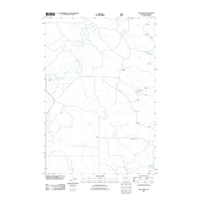
2011 Map of Belltower
USGS Topo · Published 2011About this map
Sykes Corner serves as a lone junction in this corner of Carter County, where rural life is defined by the management of water across a high plains landscape. The drainage of Boxelder Creek and its tributaries, including Speelmon Creek and Devils Canyon Creek, shape the terrain. The map reveals an extensive network of small impoundments such as Lampkin Gulch Reservoir, Horse Killer Reservoir, and V-Bar-S Reservoir, which are vital for ranching operations in this arid region. These reservoirs, often named for local families or landmarks, emphasize the human imprint on a landscape that otherwise follows the natural contours of Maverick Gulch and the dramatic Devils Canyon. Access is maintained through a grid of specialized routes like Curry Ranch Rd and Long Pines Rd, linking remote homesteads and grazing lands.
Find a feature on this map
24 named features on this map. Tap any name to fly to it.
Don’t see what you’re looking for? This feature index may not catch every label — zoom into the map to look around manually.
Map Details
Editions of this 2011 Belltower Map
This is the sole edition of this map. No revisions or reprints were ever made.
Other maps of this area

1954 · Ekalaka
USGS Topo · 1:250,000

1956 · Ekalaka
USGS Topo · 1:250,000

1958 · Ekalaka
USGS Topo · 1:250,000

1965 · Ekalaka
USGS Topo · 1:250,000

1980 · Taylor Hills
USGS Topo · 1:24,000

1980 · Belltower
USGS Topo · 1:24,000
1980 · Rustler Divide
USGS Topo · 1:24,000

1980 · Belltower Butte
USGS Topo · 1:24,000

1980 · Camp Needmore
USGS Topo · 1:24,000
1980 · School Section Creek
USGS Topo · 1:24,000