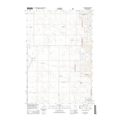
2014 Map of Belltower
USGS Topo · Published 2014About this map
Belltower and its surrounding landscape in Carter County are defined by a network of drainage creeks and small-scale water management projects typical of eastern Montana ranching country. The map documents numerous named catchments such as Horse Killer Reservoir, V-Bar-S Reservoir, and Devils Canyon Reservoir, which capture runoff from seasonal waterways like Boxelder Creek. These features illustrate the essential infrastructure required to support livestock and agriculture in a semi-arid environment.
Find a feature on this map
27 named features on this map. Tap any name to fly to it.
Don’t see what you’re looking for? This feature index may not catch every label — zoom into the map to look around manually.
Map Details
Editions of this 2014 Belltower Map
This is the sole edition of this map. No revisions or reprints were ever made.
Other maps of this area

1954 · Ekalaka
USGS Topo · 1:250,000

1956 · Ekalaka
USGS Topo · 1:250,000

1958 · Ekalaka
USGS Topo · 1:250,000

1965 · Ekalaka
USGS Topo · 1:250,000

1980 · Taylor Hills
USGS Topo · 1:24,000

1980 · Belltower
USGS Topo · 1:24,000
1980 · Rustler Divide
USGS Topo · 1:24,000

1980 · Belltower Butte
USGS Topo · 1:24,000

1980 · Camp Needmore
USGS Topo · 1:24,000
1980 · School Section Creek
USGS Topo · 1:24,000