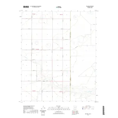
2020 Map of Bellview
USGS Topo · Published 2020About this map
The New Mexico Texas state line bisects this eastern New Mexico landscape, where the agricultural plateaus of Curry County meet the high plains of the Texas Panhandle. The small settlements of Bellview and Hollene anchor a regular grid of county roads, including Curry Road 41 and Curry Road 36, which facilitate transit across these sparsely populated townships. The terrain is characterized by the winding path of Tierra Blanca Creek, which cuts through the southern portion of the quadrangle, introducing topographic relief to the otherwise geometric layout of section lines. This 2020 survey illustrates the modern rural infrastructure along the border, dominated by ranching and local transit routes like Ranch Road 1058 and State Line Road.
Find a feature on this map
33 named features on this map. Tap any name to fly to it.
Don’t see what you’re looking for? This feature index may not catch every label — zoom into the map to look around manually.
Map Details
Editions of this 2020 Bellview Map
This is the sole edition of this map. No revisions or reprints were ever made.
Other maps of this area

1954 · Clovis
USGS Topo · 1:250,000

1957 · Pleasant Hill
USGS Topo · 1:62,500

1958 · Clovis
USGS Topo · 1:250,000

1965 · Rhea
USGS Topo · 1:24,000

1971 · Mustang Lake
USGS Topo · 1:24,000

1971 · Garcia Lake
USGS Topo · 1:24,000

1971 · Day Canyon
USGS Topo · 1:24,000

1971 · Broadview
USGS Topo · 1:24,000

1971 · Bellview
USGS Topo · 1:24,000
1971 · Endee Hill
USGS Topo · 1:24,000