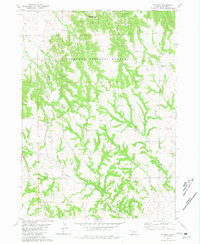
1980 Map of Belmont
USGS Topo · Published 1981About this map
Belmont serves as the focal point for this landscape in Dawes County, where the Burlington Northern railroad cuts through the terrain. The presence of the Belmont Tunnel and the nearby Belmont Cem provides a detailed look at the infrastructure and local history of this Nebraska panhandle community. Much of the northern half of the area is occupied by the Nebraska National Forest and the Ponderosa State Wildlife Area, characterized by complex drainage systems such as White Clay Creek, Saw Log Creek, and Rock Canyon. The map reveals a balance between managed public lands and the essential rail corridor that defined local transport. Elevated landmarks like Squaw Mound and the rural network along Table Road illustrate the topography that challenged early railroad engineering in this region.
Find a feature on this map
19 named features on this map. Tap any name to fly to it.
Don’t see what you’re looking for? This feature index may not catch every label — zoom into the map to look around manually.
Map Details
Editions of this 1980 Belmont Map
This is the sole edition of this map. No revisions or reprints were ever made.
Other maps of this area

1946 · Box Butte Reservoir West
USGS Topo · 1:24,000

1948 · Box Butte Reservoir West
USGS Topo · 1:24,000

1951 · Marsland
USGS Topo · 1:62,500

1955 · Alliance
USGS Topo · 1:250,000

1957 · Alliance
USGS Topo · 1:250,000

1958 · Alliance
USGS Topo · 1:250,000

1980 · Crow Butte
USGS Topo · 1:24,000
1980 · Coffee Mill Butte SW
USGS Topo · 1:24,000

1980 · Dead Mans Creek
USGS Topo · 1:24,000
1980 · Chimney Butte
USGS Topo · 1:24,000