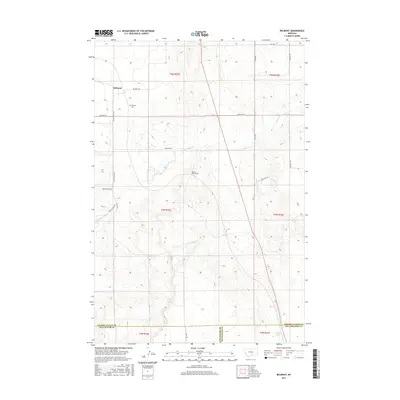
2017 Map of Belmont
USGS Topo · Published 2017About this map
Belmont occupies a prominent position in this Montana landscape, situated at the intersection of several local routes like Cushman Rd and Custer Gulch Rd. The settlement is anchored by the Belmont Cem, while the surrounding terrain is marked by the winding course of Painted Robe Cr and Cottonwood Cr. A notable engineering landmark, the Painted Robe Tunnel, sits just east of the main road network, indicating the historical influence of infrastructure on this rural area.
Find a feature on this map
27 named features on this map. Tap any name to fly to it.
Don’t see what you’re looking for? This feature index may not catch every label — zoom into the map to look around manually.
Map Details
Editions of this 2017 Belmont Map
This is the sole edition of this map. No revisions or reprints were ever made.
Other maps of this area

1889 · Big Snowy Mountain
USGS Topo · 1:250,000

1893 · Big Snowy Mountain
USGS Topo · 1:250,000

1954 · Roundup
USGS Topo · 1:250,000

1958 · Roundup
USGS Topo · 1:250,000

1979 · Roundup
USGS Topo · 1:100,000

1979 · Bundy
USGS Topo · 1:24,000

1979 · Lavina
USGS Topo · 1:24,000

1979 · Belmont
USGS Topo · 1:24,000
1979 · Broadview East
USGS Topo · 1:24,000
1980 · Broadview West
USGS Topo · 1:24,000