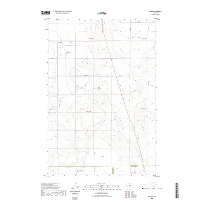
2020 Map of Belmont
USGS Topo · Published 2020About this map
Belmont stands as the central hub of this Montana landscape, where the local history is anchored by the Belmont Cem and a network of named country roads. The topography is defined by the winding course of Painted Robe Creek and Cottonwood Cr, which carve through the terrain as they flow toward the south and east. A notable engineering landmark, the Painted Robe Tunnel, sits along the creek bed, indicating the significance of water management and transport infrastructure in this rural corridor. The area is intersected by the Buffalo Hwy and several functional routes like Granary Rd and Cushman Rd, which connect various sections and ranges. This 2020 map also captures the tri-county intersection where Golden Valley, Stillwater, and Yellowstone counties meet, illustrating the administrative boundaries that overlay this expansive grazing and agricultural region.
Find a feature on this map
29 named features on this map. Tap any name to fly to it.
Don’t see what you’re looking for? This feature index may not catch every label — zoom into the map to look around manually.
Map Details
Editions of this 2020 Belmont Map
This is the sole edition of this map. No revisions or reprints were ever made.
Other maps of this area

1889 · Big Snowy Mountain
USGS Topo · 1:250,000

1893 · Big Snowy Mountain
USGS Topo · 1:250,000

1954 · Roundup
USGS Topo · 1:250,000

1958 · Roundup
USGS Topo · 1:250,000

1979 · Roundup
USGS Topo · 1:100,000

1979 · Bundy
USGS Topo · 1:24,000

1979 · Lavina
USGS Topo · 1:24,000

1979 · Belmont
USGS Topo · 1:24,000
1979 · Broadview East
USGS Topo · 1:24,000
1980 · Broadview West
USGS Topo · 1:24,000