
1979 Map of Belmont
USGS Topo · Published 1980About this map
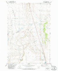
Belmont stands as a primary point of reference in this late 1970s landscape, situated along the Burlington Northern railroad line. This area of Golden Valley County is defined by the winding paths of Painted Robe Creek and Cottonwood Creek, which carve through the high plains. A significant engineering feature, the Painted Robe Tunnel, facilitates the passage of the rail line through the local topography, while a major Pipeline cuts a long diagonal across the eastern half of the quadrangle. Several wells and a small Alkali Pond indicate the water management needs of the region, where natural springs like Spring are dispersed between the drainage basins. The map also records the jurisdictional boundaries between Golden Valley, Stillwater, and Yellowstone counties, providing a clear picture of the rural infrastructure and land use of the era.
Find a feature on this map
12 named features on this map. Tap any name to fly to it.
Don’t see what you’re looking for? This feature index may not catch every label — zoom into the map to look around manually.
Map Details
Editions of this 1979 Belmont Map
2 editions found
Other maps of this area

1889 · Big Snowy Mountain
USGS Topo · 1:250,000

1893 · Big Snowy Mountain
USGS Topo · 1:250,000

1954 · Roundup
USGS Topo · 1:250,000

1958 · Roundup
USGS Topo · 1:250,000

1979 · Roundup
USGS Topo · 1:100,000

1979 · Bundy
USGS Topo · 1:24,000

1979 · Lavina
USGS Topo · 1:24,000
1979 · Broadview East
USGS Topo · 1:24,000
1980 · Broadview West
USGS Topo · 1:24,000
1980 · Broadview NE
USGS Topo · 1:24,000