
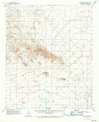
1962 Map of Belmont Mts
USGS Topo · Published 1963About this map
The Belmont Mountains dominate this central Arizona desert landscape, rising abruptly from the Hassayampa Plain and the Tonapah Desert. This 1962 field-checked survey documents a region defined by its historic mineral extraction and sparse water sources. Mining activity is concentrated in the high country, where the Tonopah-Belmont Mine, Morning Star Mine, and Black Pearl Mine are located alongside various wells like Tiger Well and Upper Belmont Well.
Find a feature on this map
47 named features on this map. Tap any name to fly to it.
Don’t see what you’re looking for? This feature index may not catch every label — zoom into the map to look around manually.
Map Details
Editions of this 1962 Belmont Mts Map
2 editions found
Other maps of this area

1942 · Vicksburg
USGS Topo · 1:250,000

1954 · Phoenix
USGS Topo · 1:250,000

1957 · Phoenix
USGS Topo · 1:250,000

1957 · White Tank Mts.
USGS Topo · 1:62,500

1958 · Phoenix
USGS Topo · 1:250,000

1958 · Buckeye NW
USGS Topo · 1:24,000

1958 · Buckeye
USGS Topo · 1:62,500

1960 · Phoenix
USGS Topo · 1:250,000

1961 · Vulture Mountains
USGS Topo · 1:62,500

1961 · Big Horn Mts
USGS Topo · 1:62,500