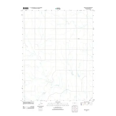
2012 Map of Beloit SW
USGS Topo · Published 2012About this map
Pleasant View Cem serves as a quiet landmark in this section of Mitchell County, situated amidst a drainage network defined by the winding paths of several creeks. The landscape is carved by the northern flow of Leban Cr and the westward reaches of Salt Cr, while Little Cr and Rock Cr cross the southern sections of the terrain. A rigid grid of rural corridors, including 140th Rd, facilitates movement across this agricultural region, reflecting the systematic land division of the Kansas plains. This survey provides a clear view of the water sources and local landmarks that have guided residents for generations, capturing the rural character of the county as it appeared in the early 21st century.
Find a feature on this map
6 named features on this map. Tap any name to fly to it.
Don’t see what you’re looking for? This feature index may not catch every label — zoom into the map to look around manually.
Map Details
Editions of this 2012 Beloit SW Map
This is the sole edition of this map. No revisions or reprints were ever made.
Other maps of this area

1894 · Beloit
USGS Topo · 1:125,000

1953 · Solomon Rapids
USGS Topo · 1:24,000

1953 · Glen Elder South
USGS Topo · 1:24,000

1953 · Beloit
USGS Topo · 1:24,000

1955 · Beloit
USGS Topo · 1:250,000

1959 · Beloit
USGS Topo · 1:250,000
1964 · Barnard
USGS Topo · 1:24,000
1964 · Beloit SE
USGS Topo · 1:24,000

1968 · Beloit SW
USGS Topo · 1:24,000

1968 · Lincoln NW
USGS Topo · 1:24,000