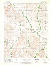
1964 Map of Barnard
USGS Topo · Published 1965About this map
Barnard serves as the central hub of this mid-1960s Kansas landscape, situated where the Atchison Topeka and Santa Fe railroad crosses the winding path of Salt Creek. The town's local infrastructure is visible in detail, including the nearby Sewage Disposal Ponds, while the surrounding rural landscape is divided into townships like Scott and Beaver. This area is defined by a dense network of tributaries, including Rattlesnake Creek, Fifth Creek, and Prosser Creek, which carve through the terrain and dictate the placement of early infrastructure. The map is a valuable resource for genealogical research, documenting several local burial grounds such as Milo Cem to the east and Union Valley Cem to the west. Evidence of local industry and resource extraction is scattered throughout the countryside, marked by numerous Gravel Pits, a Sandpit, and several Quarries.
Find a feature on this map
29 named features on this map. Tap any name to fly to it.
Don’t see what you’re looking for? This feature index may not catch every label — zoom into the map to look around manually.
Map Details
Editions of this 1964 Barnard Map
2 editions found
Other maps of this area

1892 · Minneapolis
USGS Topo · 1:125,000

1894 · Beloit
USGS Topo · 1:125,000

1952 · Glasco SW
USGS Topo · 1:24,000

1955 · Manhattan
USGS Topo · 1:250,000

1955 · Beloit
USGS Topo · 1:250,000

1956 · Manhattan
USGS Topo · 1:250,000

1957 · Manhattan
USGS Topo · 1:250,000

1959 · Beloit
USGS Topo · 1:250,000

1962 · Lincoln
USGS Topo · 1:24,000
1963 · Shady Bend
USGS Topo · 1:24,000