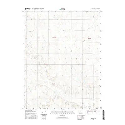
2015 Map of Beloit SW
USGS Topo · Published 2015About this map
Salt Cr and its tributaries define the agricultural layout of Mitchell County in this 2015 study. The landscape is structured by a precise grid of rural roads, including O Rd and 230 Rd, which separate the vast sectioned fields of the Public Land Survey System. This modern topographic record captures the enduring rural character of the region, where historical landmarks such as Elmira Cem and Pleasant View Cem remain as focal points for local history. The drainage patterns of Leban Cr and Little Cr illustrate the natural topography that underlies the township and range divisions, showing how early settlement patterns have persisted into the current era through the maintained section lines and waterway boundaries.
Find a feature on this map
25 named features on this map. Tap any name to fly to it.
Don’t see what you’re looking for? This feature index may not catch every label — zoom into the map to look around manually.
Map Details
Editions of this 2015 Beloit SW Map
This is the sole edition of this map. No revisions or reprints were ever made.
Other maps of this area

1894 · Beloit
USGS Topo · 1:125,000

1953 · Solomon Rapids
USGS Topo · 1:24,000

1953 · Glen Elder South
USGS Topo · 1:24,000

1953 · Beloit
USGS Topo · 1:24,000

1955 · Beloit
USGS Topo · 1:250,000

1959 · Beloit
USGS Topo · 1:250,000
1964 · Barnard
USGS Topo · 1:24,000
1964 · Beloit SE
USGS Topo · 1:24,000

1968 · Beloit SW
USGS Topo · 1:24,000

1968 · Lincoln NW
USGS Topo · 1:24,000