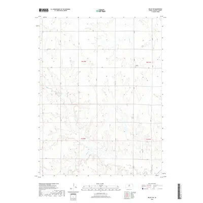
2018 Map of Beloit SW
USGS Topo · Published 2018About this map
Mitchell County farmland is defined by its deep drainages and the rigid grid of rural roads in this Mitchell County survey. The terrain is carved by the winding courses of Salt Cr and Rock Creek, which dictate the topography of the southern sections. This area remains largely agricultural, with the landscape divided into clear sections such as t8s r8w and t8s r7w. Scattered throughout these fields are quiet landmarks of local heritage, including Elmira Cem in the northwest and Pleasant View Cem to the east. These sites, along with the numerous creek systems like Leban Cr and Little Cr, provide a detailed view of the rural township structure and the natural waterways that have shaped Kansas farming life for generations.
Find a feature on this map
28 named features on this map. Tap any name to fly to it.
Don’t see what you’re looking for? This feature index may not catch every label — zoom into the map to look around manually.
Map Details
Editions of this 2018 Beloit SW Map
This is the sole edition of this map. No revisions or reprints were ever made.
Other maps of this area

1894 · Beloit
USGS Topo · 1:125,000

1953 · Solomon Rapids
USGS Topo · 1:24,000

1953 · Glen Elder South
USGS Topo · 1:24,000

1953 · Beloit
USGS Topo · 1:24,000

1955 · Beloit
USGS Topo · 1:250,000

1959 · Beloit
USGS Topo · 1:250,000
1964 · Barnard
USGS Topo · 1:24,000
1964 · Beloit SE
USGS Topo · 1:24,000

1968 · Beloit SW
USGS Topo · 1:24,000

1968 · Lincoln NW
USGS Topo · 1:24,000