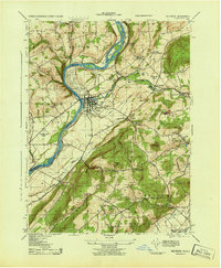
1943 Map of Belvidere
USGS Topo · Published 1943About this map
The Delaware River serves as the primary artery for this mid-war landscape, dividing New Jersey's Warren County from Pennsylvania's Northampton County. At the center, the borough of Belvidere sits at the confluence of the Delaware and the Pequest River, showing its industrial character with the Pequest Hosiery Mill and proximity to multiple rail lines, including the Belvidere Division and the Lackawanna and Western. To the east, the landscape transitions from the river valley to the prominent ridge of Jenny Jump Mountain.
Find a feature on this map
46 named features on this map. Tap any name to fly to it.
Don’t see what you’re looking for? This feature index may not catch every label — zoom into the map to look around manually.
Map Details
Editions of this 1943 Belvidere Map
This is the sole edition of this map. No revisions or reprints were ever made.
Other maps of this area

1888 · Hackettstown
USGS Topo · 1:62,500

1890 · Easton
USGS Topo · 1:62,500

1890 · High Bridge
USGS Topo · 1:62,500

1891 · Easton
USGS Topo · 1:62,500

1891 · Delaware Water Gap
USGS Topo · 1:62,500

1893 · Delaware Water Gap
USGS Topo · 1:62,500

1894 · Hackettstown
USGS Topo · 1:62,500

1898 · Hackettstown
USGS Topo · 1:62,500

1898 · High Bridge
USGS Topo · 1:62,500

1900 · Raritan
USGS Topo · 1:125,000