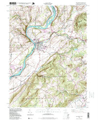
1997 Map of Belvidere
USGS Topo · Published 1999About this map
The Delaware River carves a winding boundary between Pennsylvania and New Jersey on this late-twentieth-century survey, anchoring the prominent community of Belvidere. The landscape is defined by the convergence of the Pequest River and the Delaware, creating a hub of settlement and infrastructure that includes Bridgeville Station and the industrial remnants of an Old RR Grade. The topography rises sharply from the riverbanks toward Oxford Mountain and the Jenny Jump State Forest, where the terrain transitions from river-bottom settlements to high-elevation landmarks like Mt No More.
Find a feature on this map
61 named features on this map. Tap any name to fly to it.
Don’t see what you’re looking for? This feature index may not catch every label — zoom into the map to look around manually.
Map Details
Editions of this 1997 Belvidere Map
This is the sole edition of this map. No revisions or reprints were ever made.
Other maps of this area

1888 · Hackettstown
USGS Topo · 1:62,500

1890 · Easton
USGS Topo · 1:62,500

1890 · High Bridge
USGS Topo · 1:62,500

1891 · Easton
USGS Topo · 1:62,500

1891 · Delaware Water Gap
USGS Topo · 1:62,500

1893 · Delaware Water Gap
USGS Topo · 1:62,500

1894 · Hackettstown
USGS Topo · 1:62,500

1898 · Hackettstown
USGS Topo · 1:62,500

1898 · High Bridge
USGS Topo · 1:62,500

1900 · Raritan
USGS Topo · 1:125,000