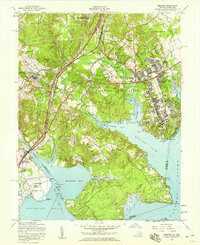
1956 Map of Belvoir
USGS Topo · Published 1959About this map
Fort Belvoir Military Reservation dominates this mid-century landscape where the Potomac River meets the intricate inlets of Accotink Bay, Pohick Bay, and Gunston Cove. The map documents a significant intersection of American heritage and modern infrastructure, featuring the grounds of Gunston Hall and Woodlawn Mansion alongside the developing transport corridor of the Shirley Memorial Highway and the Richmond Fredericksburg and Potomac RR.
Find a feature on this map
71 named features on this map. Tap any name to fly to it.
Don’t see what you’re looking for? This feature index may not catch every label — zoom into the map to look around manually.
Map Details
Editions of this 1956 Belvoir Map
This is the sole edition of this map. No revisions or reprints were ever made.
Other maps of this area

1890 · Mt. Vernon
USGS Topo · 1:125,000

1891 · Mt. Vernon
USGS Topo · 1:125,000

1894 · Mt. Vernon
USGS Topo · 1:125,000

1897 · Mt. Vernon
USGS Topo · 1:125,000

1900 · Washington
USGS Topo · 1:62,500

1913 · Indian Head
USGS Topo · 1:62,500

1915 · Fairfax
USGS Topo · 1:62,500

1923 · Indian Head
USGS Topo · 1:48,000

1925 · Indian Head
USGS Topo · 1:62,500

1927 · Quantico
USGS Topo · 1:62,500