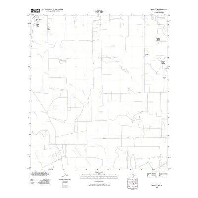
2010 Map of Ben Bolt NW
USGS Topo · Published 2010About this map
North Buena Vista Colonia and Buena Vista Colonia anchor the northwest corner of this South Texas landscape, illustrating the distinctive residential settlement patterns common to the brushlands of the Rio Grande Plain. The area is defined by a sparse network of county roads and farm-to-market routes that connect scattered communities like Goldapp Colonia and Coyote Acres Colonia. The extraction economy is clearly visible through the presence of the Koopman Gas Field and Alice Oil Field, which punctuate the agricultural surroundings. The drainage of the region relies on a series of ephemeral watercourses, including San Andreas Creek, Trinidad Creek, and Javelina Creek, which carve subtle paths through the flat terrain toward the southeast. This survey captures a moment of modern rural development where residential colonias and energy infrastructure overlap.
Find a feature on this map
36 named features on this map. Tap any name to fly to it.
Don’t see what you’re looking for? This feature index may not catch every label — zoom into the map to look around manually.
Map Details
Editions of this 2010 Ben Bolt NW Map
This is the sole edition of this map. No revisions or reprints were ever made.
Other maps of this area

1917 · Ben Bolt
USGS Topo · 1:62,500

1920 · San Diego
USGS Topo · 1:62,500

1956 · Benavides
USGS Topo · 1:62,500

1956 · Rosita Ranch
USGS Topo · 1:62,500

1956 · Laredo
USGS Topo · 1:250,000

1963 · Ben Bolt SE
USGS Topo · 1:24,000

1963 · San Diego
USGS Topo · 1:24,000
1963 · Alice North
USGS Topo · 1:24,000

1963 · Ben Bolt NW
USGS Topo · 1:24,000
1963 · Alice South
USGS Topo · 1:24,000
Featured Places
- San Diego, TX
- Buena Vista Colonia, TX
- La Masa Road Colonia, TX
- Coyote Acres, TX
- Coyote Acres Colonia, TX