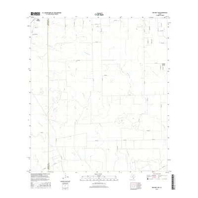
2016 Map of Ben Bolt NW
USGS Topo · Published 2016About this map
The county line between Duval Co and Jim Wells Co bisects this landscape of intermittent watercourses and South Texas ranch roads. San Diego occupies the northwestern corner, serving as a focal point for the surrounding rural territory, while the residential development of Coyote Acres is situated to the east. The terrain is defined by a dendritic network of ephemeral creeks, including San Andreas Cr, Trinidad Cr, and Javelina Cr, which carve shallow paths through the brushland. Transportation follows a grid of local county roads and trails, such as San Martin Rd and Arena Trl, alongside major routes like FM 625 and FM 1329. This survey documents a quiet rural area where large landholdings and small settlements coexist, reflecting the region's enduring ranching character into the early 21st century.
Find a feature on this map
43 named features on this map. Tap any name to fly to it.
Don’t see what you’re looking for? This feature index may not catch every label — zoom into the map to look around manually.
Map Details
Editions of this 2016 Ben Bolt NW Map
This is the sole edition of this map. No revisions or reprints were ever made.
Other maps of this area

1917 · Ben Bolt
USGS Topo · 1:62,500

1920 · San Diego
USGS Topo · 1:62,500

1956 · Benavides
USGS Topo · 1:62,500

1956 · Rosita Ranch
USGS Topo · 1:62,500

1956 · Laredo
USGS Topo · 1:250,000

1963 · Ben Bolt SE
USGS Topo · 1:24,000

1963 · San Diego
USGS Topo · 1:24,000
1963 · Alice North
USGS Topo · 1:24,000

1963 · Ben Bolt NW
USGS Topo · 1:24,000
1963 · Alice South
USGS Topo · 1:24,000
Featured Places
- San Diego, TX
- Buena Vista Colonia, TX
- La Masa Road Colonia, TX
- Coyote Acres, TX
- Coyote Acres Colonia, TX