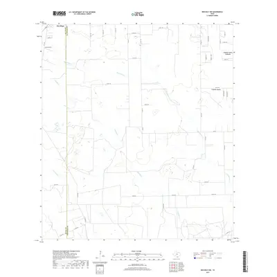
2019 Map of Ben Bolt NW
USGS Topo · Published 2019About this map
San Diego anchors the northwest corner of this South Texas landscape, where the boundary between Duval Co and Jim Wells Co carves a straight north-south line through the brush country. The terrain is defined by a dendritic network of seasonal drainages, most notably San Andreas Cr and Trinidad Cr, which wind eastward across a patchwork of large ranch tracts and rural county roads. To the east, the residential development of Coyote Acres and the Coyote Acres Colonia show the modern footprint of settlement in this region. This 2019 survey illustrates the persistent rural character of the area, where historic ranch access points like Arena Trl and San Martin Rd connect isolated homesteads to larger thoroughfares like FM 625.
Find a feature on this map
45 named features on this map. Tap any name to fly to it.
Don’t see what you’re looking for? This feature index may not catch every label — zoom into the map to look around manually.
Map Details
Editions of this 2019 Ben Bolt NW Map
This is the sole edition of this map. No revisions or reprints were ever made.
Other maps of this area

1917 · Ben Bolt
USGS Topo · 1:62,500

1920 · San Diego
USGS Topo · 1:62,500

1956 · Benavides
USGS Topo · 1:62,500

1956 · Rosita Ranch
USGS Topo · 1:62,500

1956 · Laredo
USGS Topo · 1:250,000

1963 · Ben Bolt SE
USGS Topo · 1:24,000

1963 · San Diego
USGS Topo · 1:24,000
1963 · Alice North
USGS Topo · 1:24,000

1963 · Ben Bolt NW
USGS Topo · 1:24,000
1963 · Alice South
USGS Topo · 1:24,000
Featured Places
- San Diego, TX
- Buena Vista Colonia, TX
- La Masa Road Colonia, TX
- Coyote Acres, TX
- Coyote Acres Colonia, TX