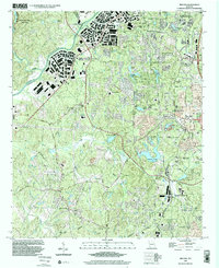
1999 Map of Ben Hill
USGS Topo · Published 2002About this map
The Chattahoochee River carves the western boundary of this Fulton County landscape, where industrial development and suburban expansion meet established community landmarks. At the close of the 20th century, the area around Ben Hill and East Point shows a complex network of residential clusters and modern infrastructure, including the Camp Creek Parkway and various reservoirs like the City of East Point Reservoirs.
Find a feature on this map
57 named features on this map. Tap any name to fly to it.
Don’t see what you’re looking for? This feature index may not catch every label — zoom into the map to look around manually.
Map Details
Editions of this 1999 Ben Hill Map
This is the sole edition of this map. No revisions or reprints were ever made.
Other maps of this area

1888 · Atlanta
USGS Topo · 1:125,000

1890 · Atlanta
USGS Topo · 1:125,000

1891 · Marietta
USGS Topo · 1:125,000

1892 · Atlanta
USGS Topo · 1:125,000

1895 · Atlanta
USGS Topo · 1:125,000

1895 · Marietta
USGS Topo · 1:125,000

1897 · Marietta
USGS Topo · 1:125,000

1901 · Marietta
USGS Topo · 1:125,000

1953 · Atlanta
USGS Topo · 1:250,000

1954 · Palmetto
USGS Topo · 1:24,000