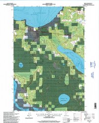
1996 Map of Bena
USGS Topo · Published 1998About this map
The town of Bena serves as a small hub within a landscape dominated by water and federally managed forests in the late twentieth century. Located within the Leech Lake Indian Reservation, the area is defined by the massive southern expanse of Lake Winnibigoshish and the eastern reach of Leech Lake. The Burlington Northern railroad cuts a straight path across the terrain, running parallel to a major Pipeline, signaling the industrial transport corridors that bisect this wooded region. Conservation efforts are evident through the Waterfowl Game Refuge designation at Drumbeater Lake and Hole-in-Bog Lake. For those researching local family history, the map identifies a Cemetery north of town and Fairview Cemetery to the southwest. The geography is shared between the Chippewa National Forest and the Bowstring State Forest, illustrating the complex overlay of tribal, state, and federal land management in northern Minnesota.
Find a feature on this map
16 named features on this map. Tap any name to fly to it.
Don’t see what you’re looking for? This feature index may not catch every label — zoom into the map to look around manually.
Map Details
Editions of this 1996 Bena Map
This is the sole edition of this map. No revisions or reprints were ever made.
Other maps of this area

1954 · Bemidji
USGS Topo · 1:250,000

1957 · Bemidji
USGS Topo · 1:250,000

1958 · Bemidji
USGS Topo · 1:250,000

1971 · Nushka Lake
USGS Topo · 1:24,000

1971 · Raven Lake
USGS Topo · 1:24,000

1971 · Bena
USGS Topo · 1:24,000
1971 · Bena NW
USGS Topo · 1:24,000
1971 · Federal Dam
USGS Topo · 1:24,000

1971 · Portage Lake
USGS Topo · 1:24,000
1971 · Boy River
USGS Topo · 1:24,000