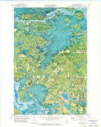
1971 Map of Boy River
USGS Topo · Published 1974About this map
The Boy River settlement sits at a vital hydrologic junction in north-central Minnesota, where the Leech Lake River and the Boy River navigate a landscape of wetlands and timber. This 1971 orthophotomap, derived from 1969 aerial photography, reveals the intricate relationship between the water and the land within the Chippewa National Forest and Bowstring State Forest. The Soo Line railroad cuts a straight diagonal across the southern swamps, providing a stark industrial contrast to the meandering riverbanks. Local history is anchored by the Arlington Cem and the Boy River Lookout Tower, which served as a critical vantage point for forest management. The presence of several Gravel Pits suggests the localized extraction industries that supported road development through the surrounding townships of Salem and Wahnena.
Find a feature on this map
19 named features on this map. Tap any name to fly to it.
Don’t see what you’re looking for? This feature index may not catch every label — zoom into the map to look around manually.
Map Details
Editions of this 1971 Boy River Map
This is the sole edition of this map. No revisions or reprints were ever made.
Other maps of this area

1954 · Bemidji
USGS Topo · 1:250,000

1954 · Hibbing
USGS Topo · 1:250,000

1957 · Bemidji
USGS Topo · 1:250,000

1957 · Hibbing
USGS Topo · 1:250,000

1958 · Bemidji
USGS Topo · 1:250,000

1958 · Hibbing
USGS Topo · 1:250,000

1964 · Hibbing
USGS Topo · 1:250,000

1970 · Ball Club
USGS Topo · 1:24,000
1971 · Remer
USGS Topo · 1:24,000

1971 · Nushka Lake
USGS Topo · 1:24,000