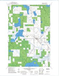
1971 Map of Remer
USGS Topo · Published 1973About this map
The town of Remer serves as a central hub within the sprawling Chippewa National Forest during the late 1960s and early 1970s. The landscape is defined by its complex hydrography, featuring major water bodies like Big Sand Lake and Big Rice Lake, alongside numerous smaller basins such as Wahneshin Lake and Grave Lake. Transportation and industry are anchored by the Soo Line railroad passing through the village, which is also home to the Remer Municipal Airport and a local Athletic Field. The presence of several Gravel Pits and sandpits scattered near the forest boundaries suggests active resource extraction during this period. To the east, the Willow River and Birch Branch drain the marshy terrain of the Walker Ranger District, illustrating the transition between open water and the dense woods of north-central Minnesota.
Find a feature on this map
27 named features on this map. Tap any name to fly to it.
Don’t see what you’re looking for? This feature index may not catch every label — zoom into the map to look around manually.
Map Details
Editions of this 1971 Remer Map
2 editions found
Other maps of this area

1953 · Duluth
USGS Topo · 1:250,000

1953 · Brainerd
USGS Topo · 1:250,000

1954 · Bemidji
USGS Topo · 1:250,000

1954 · Hibbing
USGS Topo · 1:250,000

1957 · Brainerd
USGS Topo · 1:250,000

1957 · Bemidji
USGS Topo · 1:250,000

1957 · Hibbing
USGS Topo · 1:250,000

1958 · Bemidji
USGS Topo · 1:250,000

1958 · Hibbing
USGS Topo · 1:250,000

1958 · Brainerd
USGS Topo · 1:250,000