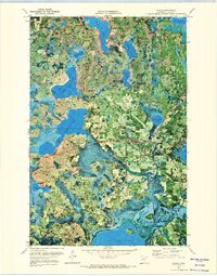
1971 Map of Remer
USGS Topo · Published 1974About this map
Remer serves as the central hub of this northern Minnesota orthophotomap, situated at a crossroads within the sprawling Chippewa National Forest. The 1971 survey combines traditional topographic contours with aerial photography, revealing a landscape defined by an intricate network of glacial lakes and wetlands. To the west, the massive Big Sand Lake and its smaller counterpart, Little Sand Lake, dominate the terrain, while the southern boundary is marked by the expansive waters of Big Rice Lake.
Find a feature on this map
22 named features on this map. Tap any name to fly to it.
Don’t see what you’re looking for? This feature index may not catch every label — zoom into the map to look around manually.
Map Details
Editions of this 1971 Remer Map
2 editions found
Other maps of this area

1953 · Duluth
USGS Topo · 1:250,000

1953 · Brainerd
USGS Topo · 1:250,000

1954 · Bemidji
USGS Topo · 1:250,000

1954 · Hibbing
USGS Topo · 1:250,000

1957 · Brainerd
USGS Topo · 1:250,000

1957 · Bemidji
USGS Topo · 1:250,000

1957 · Hibbing
USGS Topo · 1:250,000

1958 · Bemidji
USGS Topo · 1:250,000

1958 · Hibbing
USGS Topo · 1:250,000

1958 · Brainerd
USGS Topo · 1:250,000