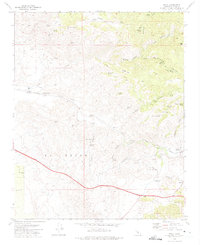
1972 Map of Bena
USGS Topo · Published 1975About this map
Southern Pacific tracks wind through the foothills of the Tehachapi Mountains on this 1972 survey, following the path of Caliente Creek. The map documents a landscape defined by ranching and rail infrastructure, where small sidings and junctions like Bena, Ilmon, and Bealville provided essential links for the region's transport network. A variety of springs, including Miller Spring and Rodeo Spring, are noted throughout the terrain, highlighting the critical nature of water sources in this dry environment.
Find a feature on this map
45 named features on this map. Tap any name to fly to it.
Don’t see what you’re looking for? This feature index may not catch every label — zoom into the map to look around manually.
Map Details
Editions of this 1972 Bena Map
4 editions found
Other maps of this area

1914 · Caliente
USGS Topo · 1:125,000

1929 · Bena
USGS Topo · 1:31,680

1930 · Bear Mountain
USGS Topo · 1:31,680

1930 · Arvin
USGS Topo · 1:31,680

1931 · Edison
USGS Topo · 1:31,680

1932 · Bena
USGS Topo · 1:31,680

1933 · Arvin
USGS Topo · 1:31,680

1933 · Bear Mountain
USGS Topo · 1:31,680

1943 · Cummings Mountain
USGS Topo · 1:62,500

1943 · Breckenridge Mountain
USGS Topo · 1:62,500