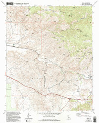
1972 Map of Bena
USGS Topo · Published 1994About this map
Caliente Creek carves a deep path through the southern Sierra Nevada foothills in this early 1970s survey, dictating the course of essential transportation routes in eastern Kern County. The map details a vital rail and road corridor connecting the small settlements of Bena, Ilmon, and Bealville along the winding Bena Road. These outposts, often centered on rail sidings or benchmarks, served as critical points of contact for the surrounding cattle country. In the rugged highlands, the landscape is defined by vast tracts of the El Tejon ranch and numerous family-named landmarks like Walker Basin and Pampa Peak. Local history is preserved in the location of the Cem near Bealville and the Rock House (Ruins) in the north. A high density of springs, including Rattlesnake Spring and Hog Camp Spring, highlights the critical importance of water management for livestock in this arid, canyon-cut terrain.
Find a feature on this map
47 named features on this map. Tap any name to fly to it.
Don’t see what you’re looking for? This feature index may not catch every label — zoom into the map to look around manually.
Map Details
Editions of this 1972 Bena Map
4 editions found
Other maps of this area

1914 · Caliente
USGS Topo · 1:125,000

1929 · Bena
USGS Topo · 1:31,680

1930 · Bear Mountain
USGS Topo · 1:31,680

1930 · Arvin
USGS Topo · 1:31,680

1931 · Edison
USGS Topo · 1:31,680

1932 · Bena
USGS Topo · 1:31,680

1933 · Arvin
USGS Topo · 1:31,680

1933 · Bear Mountain
USGS Topo · 1:31,680

1943 · Cummings Mountain
USGS Topo · 1:62,500

1943 · Breckenridge Mountain
USGS Topo · 1:62,500