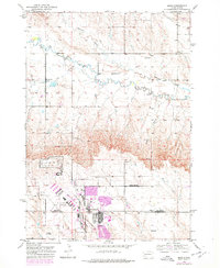
1953 Map of Bend
USGS Topo · Published 1978About this map
Ellsworth Air Force Base dominates the southern portion of this landscape, its expansive grounds and infrastructure marking a significant military presence on the plains during the mid-20th century. The map illustrates the boundary between Meade and Pennington Counties, showing a rural transition where the high ground drops toward the drainage basins of Antelope Creek and Elk Creek. Smaller centers of local activity are scattered across the terrain, including the community of Bend and several rural educational sites such as Bend Sch, Elk Dale Sch, and Pleasant Hill Sch. This edition includes later revisions highlighted in purple, which indicate the expansion of urban areas and technical facilities near the base, while traditional landmarks like the Radio Towers and several Gravel Pits document the industrial and communication infrastructure that supported the growing region.
Find a feature on this map
11 named features on this map. Tap any name to fly to it.
Don’t see what you’re looking for? This feature index may not catch every label — zoom into the map to look around manually.
Map Details
Editions of this 1953 Bend Map
2 editions found
Other maps of this area

1893 · Rapid
USGS Topo · 1:125,000

1898 · Rapid
USGS Topo · 1:125,000

1903 · Rapid
USGS Topo · 1:125,000

1953 · Bend
USGS Topo · 1:24,000

1953 · Rapid City 1 SW
USGS Topo · 1:24,000

1953 · Boxelder
USGS Topo · 1:24,000

1953 · Rapid City East
USGS Topo · 1:24,000

1953 · Rapid City NW
USGS Topo · 1:24,000

1953 · New Underwood SW
USGS Topo · 1:24,000

1953 · Hereford SW
USGS Topo · 1:24,000