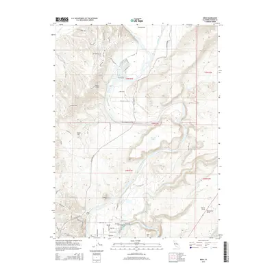
2015 Map of Bend
USGS Topo · Published 2015About this map
The Sacramento River carves a deep path through Tehama County, creating the dramatic topographical features that define this region. The small settlement of Bend sits at a prominent curve in the river, served by the historical transit corridor of Jellys Ferry Rd and the Jellys Ferry Bridge. This 2015 survey illustrates a landscape where modern development, such as the residential aviation community at Lake California Air Park, meets the established ranching and agricultural heritage represented by Saron Fruit Colony Rd. The terrain is characterized by volcanic mesas and distinct peaks, including Table Mtn and Lookout Mtn, while the river itself flows through the constricted narrows of Iron Canyon. Near the northern boundary, Bloody Island stands as a landmark within the river's channel, surrounded by numerous tributaries like Battle Creek and Paynes Creek that drain into the central valley.
Find a feature on this map
70 named features on this map. Tap any name to fly to it.
Don’t see what you’re looking for? This feature index may not catch every label — zoom into the map to look around manually.
Map Details
Editions of this 2015 Bend Map
This is the sole edition of this map. No revisions or reprints were ever made.
Other maps of this area

1890 · Red Bluff
USGS Topo · 1:250,000

1894 · Red Bluff
USGS Topo · 1:250,000

1905 · Tehama
USGS Topo · 1:62,500

1944 · Tuscan Buttes
USGS Topo · 1:62,500

1947 · Tuscan Buttes
USGS Topo · 1:62,500

1947 · Anderson
USGS Topo · 1:62,500

1948 · Anderson
USGS Topo · 1:62,500

1951 · Red Bluff East
USGS Topo · 1:24,000

1951 · Red Bluff West
USGS Topo · 1:24,000
1951 · Tuscan Springs
USGS Topo · 1:24,000