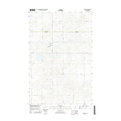
2014 Map of Benedict
USGS Topo · Published 2014About this map
Benedict serves as the central hub of this prairie landscape, situated near the border of Ward Co and McLean Co. The settlement's grid is clearly defined by local thoroughfares such as Main St and 3rd Ave, reflecting the systematic agricultural development of the region. To the northwest, the basin of McMann Lake provides a significant hydrological marker in an area otherwise characterized by numerous small prairie potholes and depressions. The map detail highlights the dense network of rural routes, including 28th St NW and 23rd Ave NW, which facilitated transport across these North Dakota plains. This topography illustrates the enduring township-and-range surveying patterns that have shaped land use and residency in the northern plains into the early 21st century.
Find a feature on this map
25 named features on this map. Tap any name to fly to it.
Don’t see what you’re looking for? This feature index may not catch every label — zoom into the map to look around manually.
Map Details
Editions of this 2014 Benedict Map
This is the sole edition of this map. No revisions or reprints were ever made.
Other maps of this area

1929 · Coleharbor
USGS Topo · 1:62,500

1929 · Benedict
USGS Topo · 1:62,500

1929 · Kongsberg
USGS Topo · 1:62,500

1947 · Turtle Lake
USGS Topo · 1:62,500

1954 · McClusky
USGS Topo · 1:250,000

1958 · McClusky
USGS Topo · 1:250,000

1974 · Benedict SE
USGS Topo · 1:24,000
1974 · Benedict NW
USGS Topo · 1:24,000
1974 · Kongsberg SW
USGS Topo · 1:24,000
1974 · Kongsberg NW
USGS Topo · 1:24,000