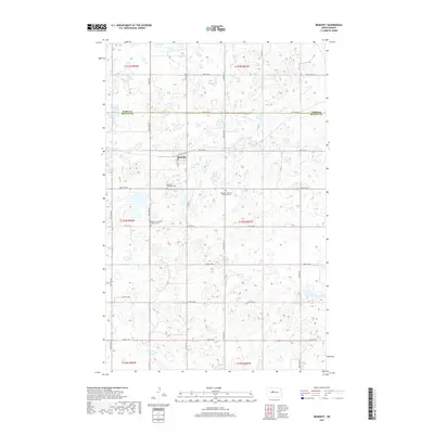
2017 Map of Benedict
USGS Topo · Published 2017About this map
The small prairie settlement of Benedict sits at the heart of this North Dakota landscape, straddling the line between the northern townships and the agricultural expanse to the south. This 2017 survey shows a community anchored by its spiritual and commemorative sites, notably the Benedict Methodist Cem, Benedict Bethania Lutheran Cem, and Benedict Concordia Lutheran Cem, which serve as vital markers for local family history and genealogy. The terrain is characterized by numerous small potholes and wetlands typical of the region, with McMann Lake located in the northwest corner along the Ward and McLean County line. A structured grid of section roads like Co Hwy 23 and 29th St NW defines the movement of people and goods through these plains, connecting the centralized Po and town center to the surrounding farmsteads.
Find a feature on this map
36 named features on this map. Tap any name to fly to it.
Don’t see what you’re looking for? This feature index may not catch every label — zoom into the map to look around manually.
Map Details
Editions of this 2017 Benedict Map
This is the sole edition of this map. No revisions or reprints were ever made.
Other maps of this area

1929 · Coleharbor
USGS Topo · 1:62,500

1929 · Benedict
USGS Topo · 1:62,500

1929 · Kongsberg
USGS Topo · 1:62,500

1947 · Turtle Lake
USGS Topo · 1:62,500

1954 · McClusky
USGS Topo · 1:250,000

1958 · McClusky
USGS Topo · 1:250,000

1974 · Benedict SE
USGS Topo · 1:24,000
1974 · Benedict NW
USGS Topo · 1:24,000
1974 · Kongsberg SW
USGS Topo · 1:24,000
1974 · Kongsberg NW
USGS Topo · 1:24,000