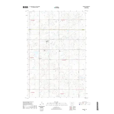
2020 Map of Benedict
USGS Topo · Published 2020About this map
Benedict sits at the heart of this North Dakota landscape, a small community organized around Main St and the local Po. The surrounding plains are defined by a meticulous grid of rural roads such as 29th St NW and 22nd Ave NW, which cross the boundary between Ward and McLean Counties. This 2020 survey reveals a deeply rooted local heritage preserved in its cemeteries, including the Benedict Concordia Lutheran Cem, Benedict Bethania Lutheran Cem, and Benedict Methodist Cem. These sites, scattered around the township lines of t150n r82w and t150n r81w, reflect the denominational history and settlement patterns of the central North Dakota prairie.
Find a feature on this map
33 named features on this map. Tap any name to fly to it.
Don’t see what you’re looking for? This feature index may not catch every label — zoom into the map to look around manually.
Map Details
Editions of this 2020 Benedict Map
This is the sole edition of this map. No revisions or reprints were ever made.
Other maps of this area

1929 · Coleharbor
USGS Topo · 1:62,500

1929 · Benedict
USGS Topo · 1:62,500

1929 · Kongsberg
USGS Topo · 1:62,500

1947 · Turtle Lake
USGS Topo · 1:62,500

1954 · McClusky
USGS Topo · 1:250,000

1958 · McClusky
USGS Topo · 1:250,000

1974 · Benedict SE
USGS Topo · 1:24,000
1974 · Benedict NW
USGS Topo · 1:24,000
1974 · Kongsberg SW
USGS Topo · 1:24,000
1974 · Kongsberg NW
USGS Topo · 1:24,000