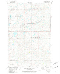
1981 Map of Benedict
USGS Topo · Published 1981About this map
Benedict serves as the primary hub of this North Dakota landscape, situated along the Soo Line tracks that cross the prairie. The terrain is characterized by numerous small water bodies and seasonal wetlands, with McMann Lake standing out in the western portion. This 1981 record captures a mix of agricultural and industrial utility, evidenced by scattered Gravel Pits and the administrative divide of the Ward Co McLean Co line. Local heritage is rooted in locations like the Concordia Cem and small named locales such as Berg and Stone. The southern edge transitions toward the Snake Creek area, while large topographic features including Iota Flat, Greely, and Andrews define the broader drainage patterns of the region during this era of photogrammetric mapping.
Find a feature on this map
15 named features on this map. Tap any name to fly to it.
Don’t see what you’re looking for? This feature index may not catch every label — zoom into the map to look around manually.
Map Details
Editions of this 1981 Benedict Map
This is the sole edition of this map. No revisions or reprints were ever made.
Other maps of this area

1929 · Coleharbor
USGS Topo · 1:62,500

1929 · Benedict
USGS Topo · 1:62,500

1929 · Kongsberg
USGS Topo · 1:62,500

1947 · Turtle Lake
USGS Topo · 1:62,500

1954 · McClusky
USGS Topo · 1:250,000

1958 · McClusky
USGS Topo · 1:250,000

1974 · Benedict SE
USGS Topo · 1:24,000
1974 · Benedict NW
USGS Topo · 1:24,000
1974 · Kongsberg SW
USGS Topo · 1:24,000
1974 · Kongsberg NW
USGS Topo · 1:24,000