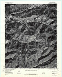
1976 Map of Benham
USGS Topo · Published 1981About this map
Benham and Lynch appear as dense ribbon settlements tucked into the narrow valleys of Harlan County, Kentucky, in this orthophotomap based on 1976 aerial photography. The imagery reveals the stark, sharp-ridged topography of the Appalachian coal country, where development is strictly confined to the level ground along Looney Creek. Further north, Cumberland and Blair occupy the banks of the Poor Fork Cumberland River, showing the heavy infrastructure and transport patterns required by the local mining industry. This specific orthophotograph, produced in cooperation with the Virginia Division of Mineral Resources, provides a rare visual record of the land surface before decades of subsequent reclamation and industrial change altered these steep slopes. The contrast between the dark, forested ridges and the light-toned urban corridors illustrates the extreme geographic constraints of these mountain communities.
Find a feature on this map
8 named features on this map. Tap any name to fly to it.
Don’t see what you’re looking for? This feature index may not catch every label — zoom into the map to look around manually.
Map Details
Editions of this 1976 Benham Map
This is the sole edition of this map. No revisions or reprints were ever made.
Other maps of this area

1887 · Jonesville
USGS Topo · 1:125,000

1890 · Whitesburg
USGS Topo · 1:125,000

1891 · Hazard
USGS Topo · 1:125,000

1891 · Jonesville
USGS Topo · 1:125,000

1892 · Whitesburg
USGS Topo · 1:125,000

1894 · Estillville
USGS Topo · 1:125,000

1913 · Oven Fork
USGS Topo · 1:48,000

1915 · Whitesburg
USGS Topo · 1:62,500

1916 · Cornettsville
USGS Topo · 1:62,500

1916 · Nolansburg
USGS Topo · 1:48,000