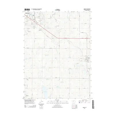
2014 Map of Bennet
USGS Topo · Published 2014About this map
Cheney and the village of Bennet anchor this agricultural landscape southeast of Lincoln, where the prairie transitions into a complex network of managed waterways. The topography is defined by the headwaters of the Little Nemaha River and the Stevens Creek drainage, punctuated by numerous flood control structures including Salt Creek Reservoir 19-B and Salt Creek Reservoir 8-B. Genealogy researchers will find the Cheney Cemetery and residential developments like those surrounding Pine Lake Reservoir. Transportation is dominated by the diagonal corridor of Nebraska Highway 2, which cuts across the grid-pattern section roads. The southern portion of the map features significant recreational water bodies, most notably Wagon Train Lake, providing a clear view of the region's mid-2010s water management and suburban expansion toward the county line.
Find a feature on this map
65 named features on this map. Tap any name to fly to it.
Don’t see what you’re looking for? This feature index may not catch every label — zoom into the map to look around manually.
Map Details
Editions of this 2014 Bennet Map
This is the sole edition of this map. No revisions or reprints were ever made.
Other maps of this area

1897 · Lincoln
USGS Topo · 1:125,000

1903 · Weeping Water
USGS Topo · 1:125,000

1929 · Weeping Water
USGS Topo · 1:125,000

1955 · Lincoln
USGS Topo · 1:250,000

1957 · Lincoln
USGS Topo · 1:250,000

1958 · Lincoln
USGS Topo · 1:250,000

1964 · Cortland
USGS Topo · 1:24,000

1964 · Roca
USGS Topo · 1:24,000

1964 · Walton
USGS Topo · 1:24,000
1964 · Lincoln
USGS Topo · 1:24,000