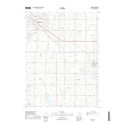
2017 Map of Bennet
USGS Topo · Published 2017About this map
The southeastern outskirts of Lincoln meet the rolling prairie of Lancaster County, where the landscape is defined by an extensive network of flood control and recreation reservoirs. Notable among these are Wagon Train Lake, Pine Lake, and several numbered basins such as Salt Cr Reservoir 19-B and Salt Cr Reservoir 8-A. The rural character of the area is anchored by the small community of Bennet to the east and the northern edge of Hickman to the south.
Find a feature on this map
86 named features on this map. Tap any name to fly to it.
Don’t see what you’re looking for? This feature index may not catch every label — zoom into the map to look around manually.
Map Details
Editions of this 2017 Bennet Map
This is the sole edition of this map. No revisions or reprints were ever made.
Other maps of this area

1897 · Lincoln
USGS Topo · 1:125,000

1903 · Weeping Water
USGS Topo · 1:125,000

1929 · Weeping Water
USGS Topo · 1:125,000

1955 · Lincoln
USGS Topo · 1:250,000

1957 · Lincoln
USGS Topo · 1:250,000

1958 · Lincoln
USGS Topo · 1:250,000

1964 · Cortland
USGS Topo · 1:24,000

1964 · Roca
USGS Topo · 1:24,000

1964 · Walton
USGS Topo · 1:24,000
1964 · Lincoln
USGS Topo · 1:24,000