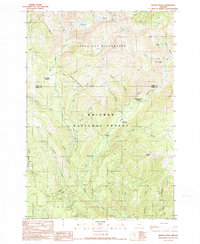
1990 Map of Bennet Peak
USGS Topo · Published 1990About this map
Eagle Cap Wilderness and the Whitman National Forest dominate this alpine terrain in the Wallowa Mountains near the boundary of Union and Baker Counties. The landscape is defined by the high-elevation drainages of West Eagle Creek and the East Fork Eagle Creek, which carved deep valleys beneath summits like Bennet Peak. Human impact in this wilderness area is restricted to the fringes, such as the Boulder Park Resort and the Two Color Guard Station, serving as outposts for forestry and recreation. Small-scale industrial activity is evidenced by the Basin Mine and a Gravel Pit in the southern reaches of the quadrangle. A series of high-altitude glacial waters, including Olive Lake, Echo Lake, and Traverse Lake, are linked by a network of primitive routes and an unnamed Trail, illustrating the remote nature of northeastern Oregon's interior before the turn of the millennium.
Find a feature on this map
43 named features on this map. Tap any name to fly to it.
Don’t see what you’re looking for? This feature index may not catch every label — zoom into the map to look around manually.
Map Details
Editions of this 1990 Bennet Peak Map
This is the sole edition of this map. No revisions or reprints were ever made.
Other maps of this area

1901 · Baker City
USGS Topo · 1:125,000

1906 · Telocaset
USGS Topo · 1:125,000

1915 · Pine
USGS Topo · 1:125,000

1954 · Eagle Cap
USGS Topo · 1:62,500

1955 · Baker
USGS Topo · 1:250,000

1955 · Grangeville
USGS Topo · 1:250,000

1957 · Sparta
USGS Topo · 1:62,500

1959 · Baker
USGS Topo · 1:250,000

1959 · Grangeville
USGS Topo · 1:250,000

1965 · China Cap
USGS Topo · 1:24,000