
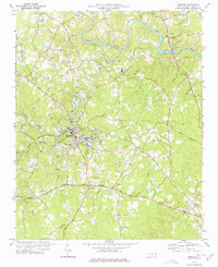
1968 Map of Bennett
USGS Topo · Published 1973About this map
Deep River carves a sinuous path through the western portion of this Piedmont landscape, defining much of the topography where Richland Creek and Brush Creek meet the main channel. The survey reflects a rural community structure centered around small crossroads and numerous country churches, which served as the primary social anchors for the surrounding farmsteads. The settlement of Bennett stands as the principal hub in the east, while smaller points like Cheeks and the Landing Field indicate the local infrastructure of the late 1960s. Genealogists will find significant value in the distribution of several houses of worship, including Maple Springs Ch, Pleasant Grove Ch, and Riverside Ch, many of which are accompanied by local cemeteries. The map also clearly delineates the tri-county borders where Randolph, Chatham, and Moore counties intersect, illustrating how these political boundaries follow both ridgelines and watercourses like Fork Creek.
Find a feature on this map
20 named features on this map. Tap any name to fly to it.
Don’t see what you’re looking for? This feature index may not catch every label — zoom into the map to look around manually.
Map Details
Editions of this 1968 Bennett Map
This is the sole edition of this map. No revisions or reprints were ever made.
Other maps of this area

1942 · Troy
USGS Topo · 1:125,000

1953 · Raleigh
USGS Topo · 1:250,000

1954 · Raleigh
USGS Topo · 1:250,000

1968 · Ramseur
USGS Topo · 1:24,000

1968 · Coleridge
USGS Topo · 1:24,000

1968 · Erect
USGS Topo · 1:24,000

1969 · Siler City
USGS Topo · 1:24,000

1970 · Bear Creek
USGS Topo · 1:24,000

1974 · Putnam
USGS Topo · 1:24,000
1977 · Robbins
USGS Topo · 1:24,000