
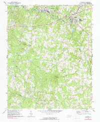
1968 Map of Ramseur
USGS Topo · Published 1973About this map
The Deep River winds through this Piedmont landscape, serving as the historical industrial corridor for the manufacturing towns of Ramseur, Franklinville, and Cedar Falls. This 1960s-era record documents the intersection of river power and rail transport, with the Southern RR Railroad following the river's path to serve the local textile mills. Away from the water, the terrain rises into prominent high points such as Pilot Mtn, Fox Mtn, and Iron Mtn. The rural sections are defined by a dense network of country churches and family landmarks, including Pleasant Cross Ch, Spoons Chapel, and Holly Spring Ch. Genealogists will find particular value in the locations of Old Salem Cem and smaller unnamed burial sites scattered across the ridges. The presence of a Filtration Plant and Sewage Disposal facility near Franklinville indicates the mid-century infrastructure supporting these established riverside communities.
Find a feature on this map
34 named features on this map. Tap any name to fly to it.
Don’t see what you’re looking for? This feature index may not catch every label — zoom into the map to look around manually.
Map Details
Editions of this 1968 Ramseur Map
2 editions found
Other maps of this area

1953 · Raleigh
USGS Topo · 1:250,000

1954 · Raleigh
USGS Topo · 1:250,000

1957 · Asheboro
USGS Topo · 1:62,500

1968 · Coleridge
USGS Topo · 1:24,000

1968 · Erect
USGS Topo · 1:24,000

1968 · Bennett
USGS Topo · 1:24,000

1970 · Randleman
USGS Topo · 1:24,000

1970 · Asheboro
USGS Topo · 1:24,000

1973 · Seagrove
USGS Topo · 1:24,000
1974 · Grays Chapel
USGS Topo · 1:24,000