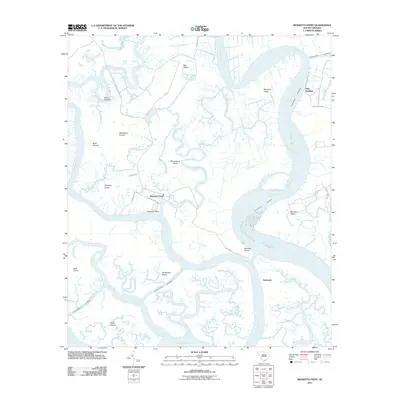
2011 Map of Bennetts Point
USGS Topo · Published 2011About this map
Bennetts Point and its associated lowcountry islands sit at the confluence of the Ashepoo River and the South Edisto River in this coastal South Carolina study. This labyrinth of tidal waterways is dominated by significant landmasses like Bear Island, Musselboro Island, and Hutchinson Island, which are separated by a complex network of smaller channels including Mosquito Creek and Crooked Creek. The map shows the path of the Intracoastal Waterway as it winds through these estuaries toward St Helena Sound at the southern edge. Human activity is concentrated along specific access points such as Pine Landing and Seabrook, connected by local routes like Bennetts Point Rd and Baldwin Ln. The landscape is characterized by its marshy island geography, featuring interestingly named locations like Hole-in-the-Wall and the Settlement Islands, reflecting a long history of maritime navigation and isolated coastal living.
Find a feature on this map
38 named features on this map. Tap any name to fly to it.
Don’t see what you’re looking for? This feature index may not catch every label — zoom into the map to look around manually.
Map Details
Editions of this 2011 Bennetts Point Map
This is the sole edition of this map. No revisions or reprints were ever made.
Other maps of this area

1918 · Green Pond
USGS Topo · 1:62,500

1919 · Edisto Island
USGS Topo · 1:62,500

1920 · St. Helena Sound
USGS Topo · 1:62,500

1943 · Edisto Island
USGS Topo · 1:62,500

1943 · Green Pond
USGS Topo · 1:62,500

1944 · Fort Fremont
USGS Topo · 1:62,500

1947 · Savannah
USGS Topo · 1:250,000

1948 · St. Helena Sound
USGS Topo · 1:62,500

1948 · Savannah
USGS Topo · 1:250,000

1956 · Frogmore
USGS Topo · 1:24,000