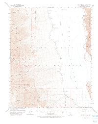
1952 Map of Bennetts Well
USGS Topo · Published 1968About this map
Death Valley (Depression) dominates this mid-century survey, revealing a landscape defined by scarce water sources and extreme elevations within the Death Valley National Monument. The map detail traces the critical reliance on isolated water points such as Bennetts Well, Shortys Well, and Eagle Borax Spring, which served as vital landmarks for early desert travelers. Along the western edge, the Panamint Range rises sharply, cut by deep drainages like Hanaupah Canyon and Johnson Canyon. Economic activity is evidenced by scattered mines and specialized Talc Mines near Galena Canyon in the south, while the eastern border is hemmed in by the Black Mountains. This 1952 field-checked record captures the topography of the basin floor, including Badwater and the ephemeral course of the Amargosa River, before modern paved access transformed the visitor experience of the monument.
Find a feature on this map
30 named features on this map. Tap any name to fly to it.
Don’t see what you’re looking for? This feature index may not catch every label — zoom into the map to look around manually.
Map Details
Editions of this 1952 Bennetts Well Map
3 editions found

Other maps of this area

1908 · Furnace Creek
USGS Topo · 1:250,000

1908 · Ballarat
USGS Topo · 1:250,000

1910 · Furnace Creek
USGS Topo · 1:250,000

1913 · Ballarat
USGS Topo · 1:250,000

1915 · Searles Lake
USGS Topo · 1:250,000

1933 · Avawatz Mountains
USGS Topo · 1:250,000

1947 · Trona
USGS Topo · 1:250,000

1948 · Trona
USGS Topo · 1:250,000

1948 · Death Valley
USGS Topo · 1:250,000

1950 · Manly Peak
USGS Topo · 1:62,500