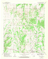
1969 Map of Bennington North
USGS Topo · Published 1971About this map
The St Louis-San Francisco railway cuts across the southern landscape of this 1969 field-checked Oklahoma quadrangle, anchoring the town of Bennington. The area is defined by a series of north-south drainage systems, including Dancing Rabbit Creek and Bokchito Creek, which divide the terrain into distinct ridges such as Tenmile Hill. For genealogists, the map is particularly rich in early settlement history, clearly marking the distinction between the railroad town and the site of Old Bennington to the north.
Find a feature on this map
31 named features on this map. Tap any name to fly to it.
Don’t see what you’re looking for? This feature index may not catch every label — zoom into the map to look around manually.
Map Details
Editions of this 1969 Bennington North Map
This is the sole edition of this map. No revisions or reprints were ever made.
Other maps of this area

1899 · Atoka
USGS Topo · 1:125,000

1900 · Atoka
USGS Topo · 1:125,000

1901 · Antlers
USGS Topo · 1:125,000

1903 · Paris
USGS Topo · 1:125,000

1912 · Antlers
USGS Topo · 1:125,000

1925 · Antlers
USGS Topo · 1:125,000

1948 · Direct
USGS Topo · 1:62,500

1949 · Direct
USGS Topo · 1:62,500

1950 · Mcalester
USGS Topo · 1:250,000

1953 · Texarkana
USGS Topo · 1:250,000