1901 Map of Antlers
USGS Topo · Published 1901About this map
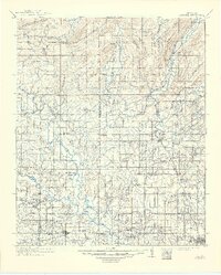
Spencer Academy stands as a central landmark in the southeastern portion of the Choctaw Nation, reflecting the educational and social structure of the territory just after the turn of the century. The terrain is defined by a complex network of waterways, including the winding Kiamichi River and the divergent paths of Clear Boggy Creek and Muddy Boggy Creek. Settlement patterns follow the topography and the newly established transportation corridors, with the St. Louis and San Francisco railroad providing a vital link for communities like Antlers, Kosoma, and Hamden. The map illustrates a transitional landscape where traditional Choctaw lands met the industrializing influence of the railroad, evidenced by the clusters of small settlements like Nelson and Mayhew that served the local agricultural and timber interests before Oklahoma statehood.
Find a feature on this map
28 named features on this map. Tap any name to fly to it.
Don’t see what you’re looking for? This feature index may not catch every label — zoom into the map to look around manually.
Map Details
Editions of this 1901 Antlers Map
This is the sole edition of this map. No revisions or reprints were ever made.
Historical Maps of Hugo Through Time
4 maps found