1901 Map of Tuskahoma
USGS Topo · Published 1901About this map
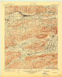
Tuskahoma serves as a focal point in this survey of the Choctaw Nation, reflecting the political and social landscape of the Indian Territory at the turn of the century. The presence of the Council House underscores the area's importance as a seat of tribal government, while remote churches like Mack Chapel and Peachland Chapel speak to the dispersed settlements in the mountain valleys. The region is defined by its topographic ridges, notably Winding Stair Mountain and Kiamichi Mountain, which dictate the paths of early industrial expansion.
Find a feature on this map
50 named features on this map. Tap any name to fly to it.
Don’t see what you’re looking for? This feature index may not catch every label — zoom into the map to look around manually.
Map Details
Editions of this 1901 Tuskahoma Map
This is the sole edition of this map. No revisions or reprints were ever made.
Historical Maps of Wilburton Through Time
3 maps found