
Loading...
Loading map...1908 Map of Tuskahoma
USGS Topo · Published 1964About this map
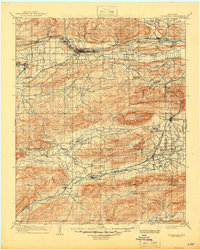
The Choctaw Council House stands as a focal point in this portion of southeastern Oklahoma, located just north of the Kiamichi River and the settlement of Tuskahoma. This era was defined by the expansion of two major rail lines through difficult terrain: the Chicago Rock Island and Pacific runs through the northern coal-rich corridor near Wilburton and Red Oak, while the St Louis and San Francisco snakes through the southern valley near Clayton.
Find a feature on this map
70 named features on this map. Tap any name to fly to it.
Don’t see what you’re looking for? This feature index may not catch every label — zoom into the map to look around manually.
Map Details
Date Portrayed1908
Date Published1964
PublisherU.S. Geological Survey
Map TypeTopographic
Scale1:125,000
Physical Dimensions17 x 21.2 inches
Editions of this 1908 Tuskahoma Map
This is the sole edition of this map. No revisions or reprints were ever made.
Historical Maps of Wilburton Through Time
3 maps found

Featured Locations
Source Details
SourceU.S. Geological Survey
CopyrightPublic Domain