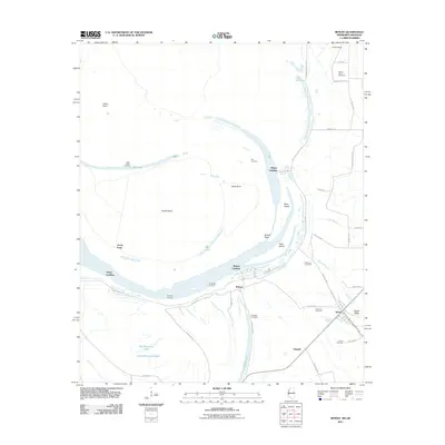
2011 Map of Benoit
USGS Topo · Published 2011About this map
Benoit and the surrounding Bolivar County delta lands are defined by the massive Mississippi River Levee, which separates the fertile cultivated plains from the shifting hydrology of the river's batture. The settlement of Bolivar sits near the river's edge, supported by numerous historic river access points such as Bolivar Landing, Buckridge Landing, and Kentucky Landing. The landscape is dotted with several family and community burial grounds, including Mount Olive Cemetery, Old Stone Cemetery, and Parthenia Cemetery, which offer valuable coordinates for genealogical research in this rural region. East of the river, the terrain transitions toward Egypt Ridge and is crisscrossed by waterways like Burrus Bayou and Deer Creek. Large oxbow features and river-formed landmasses such as Caulk Island and Goat Island illustrate the historic meandering path of the Mississippi before modern engineering stabilized its banks.
Find a feature on this map
52 named features on this map. Tap any name to fly to it.
Don’t see what you’re looking for? This feature index may not catch every label — zoom into the map to look around manually.
Map Details
Editions of this 2011 Benoit Map
This is the sole edition of this map. No revisions or reprints were ever made.
Other maps of this area

1933 · Lamont
USGS Topo · 1:62,500

1939 · Pace
USGS Topo · 1:62,500

1939 · Big Island
USGS Topo · 1:62,500

1939 · Lamont
USGS Topo · 1:62,500

1939 · Choctaw
USGS Topo · 1:62,500

1953 · Greenwood
USGS Topo · 1:250,000

1956 · Greenwood
USGS Topo · 1:250,000

1967 · Stringtown
USGS Topo · 1:24,000

1967 · Lobdell
USGS Topo · 1:24,000
1969 · Choctaw
USGS Topo · 1:62,500