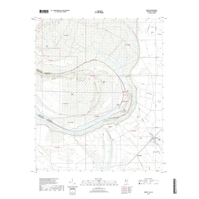
2018 Map of Benoit
USGS Topo · Published 2018About this map
Lake Whittington and the massive bend of the Mississippi River define this borderland between Bolivar County, Mississippi, and Desha County, Arkansas. The landscape is a complex network of oxbow lakes, sloughs, and islands, including Caulk Island and Mud Island, shaped by the river's historical migrations. Extensive levee systems like Levee Rd protect the low-lying agricultural plains of the Delta. In the eastern portion of the sheet, the town of Benoit sits near Egypt Ridge, serving as a focal point for the surrounding rural communities of Bolivar and Hannah. The presence of numerous family and community burial sites, such as Mount Olive Cem, Parthenia Cem, and Speckter Cem, offers significant detail for genealogical research into the families who settled this fertile but challenging riverine environment.
Find a feature on this map
67 named features on this map. Tap any name to fly to it.
Don’t see what you’re looking for? This feature index may not catch every label — zoom into the map to look around manually.
Map Details
Editions of this 2018 Benoit Map
This is the sole edition of this map. No revisions or reprints were ever made.
Other maps of this area

1933 · Lamont
USGS Topo · 1:62,500

1939 · Pace
USGS Topo · 1:62,500

1939 · Big Island
USGS Topo · 1:62,500

1939 · Lamont
USGS Topo · 1:62,500

1939 · Choctaw
USGS Topo · 1:62,500

1953 · Greenwood
USGS Topo · 1:250,000

1956 · Greenwood
USGS Topo · 1:250,000

1967 · Stringtown
USGS Topo · 1:24,000

1967 · Lobdell
USGS Topo · 1:24,000
1969 · Choctaw
USGS Topo · 1:62,500