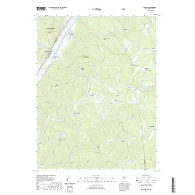
2019 Map of Bens Run
USGS Topo · Published 2019About this map
The Ohio River flows along the northwestern boundary of this 2019 survey, forming the natural border between Washington Co, Ohio and Tyler Co, West Virginia. The riverfront is marked by the Long Reach settlement and the industrial and transportation corridor at Bens Run, where the river, roads, and rail lines converge. On the Ohio side, the Wayne National Forest dominates the hills, featuring the Ohio View Trail and the Fairview Church Cem. To the east in West Virginia, the landscape is defined by the winding course of Middle Island Creek and numerous ridge-top cemeteries like Point Lookout Cem and Mount Pleasant Cem. Settlements such as Arvilla and Sugar Valley are situated along the creek valleys, connected by rural routes and significant crossings like the Shawnee Truss Bridge.
Find a feature on this map
69 named features on this map. Tap any name to fly to it.
Don’t see what you’re looking for? This feature index may not catch every label — zoom into the map to look around manually.
Map Details
Editions of this 2019 Bens Run Map
This is the sole edition of this map. No revisions or reprints were ever made.
Other maps of this area

1905 · West Union
USGS Topo · 1:62,500

1905 · New Matamoras
USGS Topo · 1:62,500

1906 · Saint Marys
USGS Topo · 1:62,500

1906 · New Martinsville
USGS Topo · 1:62,500

1924 · St Marys
USGS Topo · 1:62,500

1924 · New Martinsville
USGS Topo · 1:62,500

1924 · New Matamoras
USGS Topo · 1:62,500

1924 · West Union
USGS Topo · 1:62,500

1926 · New Martinsville
USGS Topo · 1:62,500

1926 · New Matamoras
USGS Topo · 1:62,500