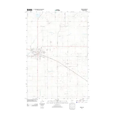
2013 Map of Benson
USGS Topo · Published 2013About this map
Benson serves as the focal point of this western Minnesota landscape, situated at the confluence of the Chippewa River and its eastern branch. The town’s grid is clearly defined by historical thoroughfares such as Atlantic Ave and Minnesota Ave, reflecting its development as a regional hub. To the north and west, the terrain is shaped by water bodies like Lake Johnson and Freeold Lake, while the agricultural character of the surrounding plains is evidenced by extensive water management systems including Judicial Ditch Number Five and County Ditch Number Eight.
Find a feature on this map
62 named features on this map. Tap any name to fly to it.
Don’t see what you’re looking for? This feature index may not catch every label — zoom into the map to look around manually.
Map Details
Editions of this 2013 Benson Map
This is the sole edition of this map. No revisions or reprints were ever made.
Other maps of this area

1953 · Saint Cloud
USGS Topo · 1:250,000

1957 · Saint Cloud
USGS Topo · 1:250,000

1958 · Saint Cloud
USGS Topo · 1:250,000

1958 · Murdock
USGS Topo · 1:24,000

1958 · Gracelock NE
USGS Topo · 1:24,000

1958 · Gracelock NW
USGS Topo · 1:24,000

1968 · De Graff
USGS Topo · 1:24,000

1968 · Lake Hassel
USGS Topo · 1:24,000

1968 · Benson
USGS Topo · 1:24,000
1968 · Clontarf North
USGS Topo · 1:24,000