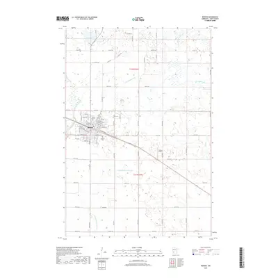
2019 Map of Benson
USGS Topo · Published 2019About this map
Benson stands as the primary hub of this Swift County landscape, situated where the Chippewa River meets a grid of residential streets including Wisconsin Ave and Atlantic Ave. This modern survey reveals a community deeply rooted in its local geography, with three distinct burial sites—Benson City Cem, Saint Francis Cem, and Our Redeemer Cem—serving as critical points of interest for genealogical research. The surrounding terrain is defined by a complex hydraulic network of natural and engineered waterways, such as the E Br Chippewa River and Judicial Ditch Number Five, which illustrate the intensive drainage and land management characteristic of Minnesota's agricultural heartland. To the east, the Lorenz Airport and various county ditches like County Ditch Number Eight point to the area's continued role as a regional center for transport and resource management.
Find a feature on this map
70 named features on this map. Tap any name to fly to it.
Don’t see what you’re looking for? This feature index may not catch every label — zoom into the map to look around manually.
Map Details
Editions of this 2019 Benson Map
This is the sole edition of this map. No revisions or reprints were ever made.
Other maps of this area

1953 · Saint Cloud
USGS Topo · 1:250,000

1957 · Saint Cloud
USGS Topo · 1:250,000

1958 · Saint Cloud
USGS Topo · 1:250,000

1958 · Murdock
USGS Topo · 1:24,000

1958 · Gracelock NE
USGS Topo · 1:24,000

1958 · Gracelock NW
USGS Topo · 1:24,000

1968 · De Graff
USGS Topo · 1:24,000

1968 · Lake Hassel
USGS Topo · 1:24,000

1968 · Benson
USGS Topo · 1:24,000
1968 · Clontarf North
USGS Topo · 1:24,000