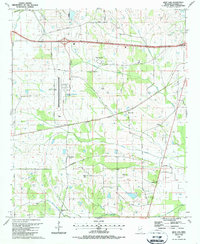
1987 Map of Bent Oak
USGS Topo · Published 1987About this map
Golden Triangle Regional Airport serves as a modern focal point for this rural Lowndes County landscape, which was revised in 1987. Surrounding the airfield, the area is defined by a dense network of family-named roads and community landmarks like the Mississippi Sheriffs Boys Ranch and the Lowndes Co Voc-Tech Sch. The settlement of Bent Oak is situated central to a transition from industrial development to traditional agricultural land, where numerous rural churches such as New Zion Ch and Springfield Ch anchor local history. Waterways like Motley Slough and Gilmer Creek meander through the terrain, flanked by numerous small cemeteries and chapels, including Shaeffer Chapel and Prairie Hill Cem, offering researchers a detailed record of the region’s mid-century rural development and social infrastructure.
Find a feature on this map
53 named features on this map. Tap any name to fly to it.
Don’t see what you’re looking for? This feature index may not catch every label — zoom into the map to look around manually.
Map Details
Editions of this 1987 Bent Oak Map
This is the sole edition of this map. No revisions or reprints were ever made.
Other maps of this area

1953 · West Point
USGS Topo · 1:250,000

1958 · West Point
USGS Topo · 1:250,000

1959 · Artesia
USGS Topo · 1:62,500

1959 · West Point
USGS Topo · 1:62,500

1960 · Caledonia
USGS Topo · 1:62,500

1960 · Columbus
USGS Topo · 1:62,500

1963 · West Point
USGS Topo · 1:250,000

1982 · West Point
USGS Topo · 1:100,000

1984 · West Point
USGS Topo · 1:250,000
1987 · Columbus North
USGS Topo · 1:24,000