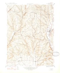
1947 Map of Benton
USGS Topo · Published 1947About this map
Fishing Creek and its many tributaries carve through the townships of north-central Columbia County, defining the settlement patterns seen in this mid-1940s survey. The village of Benton serves as a local hub, situated where the Reading railroad line follows the water's edge south toward Stillwater. This period captures a landscape transitioned from early milling to a more established rural infrastructure, evidenced by the presence of the Colen Mill and a network of district schools such as the Upper Pine Sch and the Consolidated Sch.
Find a feature on this map
40 named features on this map. Tap any name to fly to it.
Don’t see what you’re looking for? This feature index may not catch every label — zoom into the map to look around manually.
Map Details
Editions of this 1947 Benton Map
2 editions found
Other maps of this area

1894 · Bloomsburg
USGS Topo · 1:62,500

1927 · Eagles Mere
USGS Topo · 1:48,000

1932 · Eagle Mere
USGS Topo · 1:62,500

1934 · Laporte
USGS Topo · 1:62,500

1935 · Hughesville
USGS Topo · 1:62,500

1947 · Bloomsburg
USGS Topo · 1:24,000

1947 · Stillwater
USGS Topo · 1:24,000
1947 · Mifflinville
USGS Topo · 1:24,000

1947 · Benton
USGS Topo · 1:31,680
1953 · Bloomsburg
USGS Topo · 1:24,000